Water resources, civil, and environmental engineering services based in Houston, Texas
H&H Projects
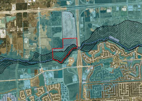
Conditional Letter of Map Revision (CLOMR) for Clear Creek Floodplain and Floodway within Proposed WaterLights Development, Harris County, Texas
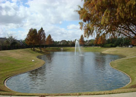
The proposed WaterLights development features residential condos, brownstones, apartments, office buildings, retail boutiques, a fresh market, 10 restaurants, two hotels, a conference facility, a water wall, and a public park along a Grand Canal waterway.
The development is an 85-acre tract in southern Harris County within the city limits of Pearland, Texas, at SH 288 and Beltway 8 intersection. The majority of the tract lies in the 100-year floodplain as defined by the FEMA’s Effective FIRM. A portion of the Tract is within the floodway. The project claims approximately 44 acres of the existing Clear Creek floodplain (including a portion of the floodway). Detention basins were designed to mitigate the change of the floodway as well as increase in runoff from the development. Modifications to the effective floodplain and floodway were proposed. The analysis result indicates no adverse impact to the Clear Creek effective base flood hazard conditions.
Three computer programs were used in the study, with the hydrologic analysis by HEC-HMS, hydraulic analysis by HEC-RAS, and the regional detention analysis by ICPR3.
Conditional Letter of Map Revision (CLOMR) for Bilal Park Estate Proposed Culverts, HCFCD Unit P146-00-00, Harris County, Texas
Hydraulic analysis to support a CLOMR request for the construction of Bilal Park Estate road crossing at the HCFCD Unit No. P146-00-00.
Bilal Park Estate is located at the northeast corner of Trickey Road and Hugh Road, to the north of Beltway 8 and west of I-45, within northern Harris County. The proposed facility (3-48” RCP culverts) is located at the proposed roadway crossing at the HCFCD Unit P146-00-00, approximately 7,200 feet from the confluence with Unit P100-00-00 (Greens Bayou).
To assess the impact due to the proposed crossing structure, a water surface profile analysis using HEC-RAS was conducted. The impact was quantified based on a comparison of water surface elevations between the existing (base) condition and the proposed (road crossing) condition computed from the model.
As the analysis result indicates no adverse impact to the FEMA effective P146-00-00 base flood hazard conditions, no floodplain or floodway boundary changes were recommended.
World Houston International Business Center, HCFCD Unit P133-00-00, City of Houston, Texas
The development consists of a 48.5-acre commercial tract and accompanying facilities, including an online detention basin and proposed culverts along HCFCD P133-00-00.
The tract is located south of Beltway 8 and west of Lee Road, to the west of I-59, within City of Houston. The HCFCD ditch P133-00-00 flows through the tract.
An online detention basin was proposed along P133-00-00 west of Lee Road to mitigate the increased post-development runoff, which outflows through two existing 72-inch culverts under Lee Road. In order to meet the detention rate requirement of 0.55 ac-ft per acre, the provided detention basin was given a volume of 26 ac-ft, in addition to the existing channel capacity. In addition, two 2-72" inlet RCP culverts were proposed, one along P133-00-00 at immediately upstream of the basin and the other at the P133-03-00 junction to the basin.
Impact analysis using HEC-RAS was performed for the 10-year and 100-year storm events. HEC-HMS was used to generate the storm runoff hydrographs and the ICPR3 program was used to route the hydrographs through the existing and proposed drainage facilities.
Results of the analysis show that the proposed development along with the construction of the proposed detention basin and culverts will not increase the storm flows in Greens Bayou P133-00-00 and P133-03-00 system, and will not cause adverse impact to the receiving waterway.
South Park Plaza, HCFCD Unit C132-01-00, Harris County, Texas
Hydraulic impact analysis prepared for the proposed culverts (3-6'x4' RCB) under a proposed subdivision road crossing at the HCFCD Unit No. C132-01-00.
The proposed culverts located south of Airport Boulevard and east of Highway 288 in Harris County, are approximately 1,900 feet from the Sims Bayou (C100-00-00) confluence with tributary C132-00-00.
To assess the impact due to the proposed culverts, a water surface profile analysis using HEC-RAS was performed. The model geometry and cross sectional data was derived based on the Harris County aerials and LiDAR data, pre-processed by using the Hec-GeoRAS tools, and converted into HEC-RAS models. The culverts at the proposed road crossing were added into the HEC-RAS models to compute flood stages and assess impacts. Both the HEC-HMS program and the Harris County Site Runoff Curve Method were used to compute the 10-year and 100-year event flows, which were adopted by the HEC-RAS models for hydraulic analysis.
Under the proposed conditions, channel improvement was proposed by lowering the existing bottom of the creek at the proposed roadway crossing to be consistent with the proposed bottom slope.
A comparison between the proposed and existing conditions model results indicates three 6'x4' RCB boxes should be used for the proposed culvert facility. With the proposed culvert structure in place, there is no adverse impact to the effective Sims Bayou 10-year and 100-year flood hazard conditions.
Texas Teo Chew Temple Addition, HCFCD Unit D100-00-00, Houston, Texas
Hydraulic impact analysis for the Texas Teo Chew Temple Addition submitted to the City of Houston, Department of Public Works and Engineering.
The project is located in southwest Harris County to the south of Bellaire Boulevard, east of Turtlewood, and immediately southwest of Brays Bayou (HCFCD Unit D100-00-00). The proposed construction is located within the floodplain limits of Brays Bayou, FEMA FIRM No. 48201C0830L. The construction includes both fill and excavation (storage mitigation) within the floodplain.
The purpose of the analysis was to verify: 1) the cumulative effect of the proposed project must result in a zero increase in the base flood elevations at any point along the bayou, 2) the project must not impede the flow of floodwaters, and 3) the project must not result in an adverse impact on the carrying capacity of the 100-year floodplain.
The effective FEMA HEC-RAS model was used and modified to evaluate the existing and proposed (fill and excavation) conditions. The results of analysis indicate that the base flood elevations, floodway limits, and floodplain storage volumes will undergo no significant changes caused by the proposed project.
Stafford Tract North of US90A, City of Stafford, Fort Bend County
A detention analysis report submitted to the TxDOT. The report provides analysis results for the existing and proposed detention facilities draining into the TxDOT US90A storm sewer system. This project had been delayed due to a very strict discharge rate required by TxDOT, which limits the outflow discharge rates from the tract to the proposed TxDOT storm sewer system along US90A. Analysis results show that the facilities will mitigate the increased runoff from the subject development and would not adversely impact the receiving storm sewer system.
Drainage Impact Analysis for Memorial Park Estates
Prepared for a request from the Texas Department of Transportation (TxDOT) - Houston District to determine the impact of the proposed Memorial Park Estates development on the existing drainage conditions in the 6800, 6900, 7004, and 7020 blocks of Old Katy Road. The impact was evaluated based on the existing hydraulic grade line (HGL) elevations in the north roadside ditch of Old Katy Road and in the proposed storm sewer to be constructed within the Old Katy Road ROW. It was concluded that the proposed drainage improvements in this area would not create a negative impact on the existing drainage conditions.
Additional Project Experiences of Key Staffs
Master Drainage Planback to top
Tule Ditch Master Drainage Plan, City of Rockport, Aransas County, Jean & Elliot
In order to relieve flooding conditions within the city, alternative detention and culvert designs were analyzed. Existing and proposed condition models were setup for the over 2,000 acres Tule Ditch Watershed. Model calibration and primary flood prone areas identification were conducted during the analysis. Final flood control plan was recommended and proposed floodplain map was delineated using ArcView GIS, ArcHydro, and HEC-GeoRAS.
Drainage Plan for Proposed Alvin Apartment Developments, Alvin, Brazoria County, Texas, Chen-hua
The project is associated with a storm water drainage plan for a proposed 30-acre multi-family development and a 132-acre single-family residential and commercial development within the Brazoria County Drainage District No. 3 (BDD#3) drainage area. Two connected regional basins along with an improved ditch were proposed to drain the entire area. Hydrology and hydraulic analysis result indicate that, with the proposed facilities in place, the future developments will not adversely impact the existing BDD#3 ditch and Mustang Bayou flood hazard conditions.
Storm Water Drainage Plan for Proposed Developments in the Upper Clodine Ditch Watershed, Fort Bend County, Texas, Chen-hua
This project consisted of a master drainage plan for a number of commercial and residential developments located within the upper Clodine Ditch (Long Point Slough) watershed. In order to meet the LID No.12’s outflow discharge rates criteria, two regional basins near the LID No.12/MUD No.50 outlet and an expansion to the FM1093 detention basin were proposed. The result of the unsteady flow HEC-RAS modeling indicates that the proposed regional basins perform equivalently to multiple on-site detentions provided in each of the future developments.
Brazoria County Master Drainage Plan, Brazoria County, Texas, Chen-hua
The project called for the revision of complete hydrologic and hydraulic models for major watersheds including Chocolate Bayou, Mustang Bayou, and the Brazos River,etc., identification of existing flooding problems, and development of recommendations regarding cost-effective and long-term solutions.
Hydrologic and Hydraulic Modelingback to top
Regional Watershed Modeling System for The San Antonio River Basin, Martinez Creek and Calaveras Creek Watersheds, Bexar County, Texas, Chen-hua
This project involved hydrologic modeling for the eastern portion of Bexar County and vicinity for an area of 150 square miles. GIS ArcMap with PrePro-2002 extension was used to delineate the sub-basin boundaries based on the Digital Elevation Model (DEM) data obtained from the National Elevation Dataset (NED), and to generate the HEC-HMS model input data framework.
White Oak Bayou Federal Flood Control Project, Harris County, Texas, Elliot
Hydrology and hydraulic analyses were performed in support of General Reevaluation Report (GRR) for Harris County Flood Control District (HCFCD). HEC-HMS and HEC-RAS models were used to evaluate the proposed White Oak Bayou Channel Improvements. The analysis results were used to determine whether the benefits obtained from the flood damage reduction plan offset the costs of the channel improvement.
Houston Airport System, Houston, Texas, James
Performed the hydraulic evaluation of the Garners Bayou realignment project at the Bush Intercontinental Airport. Updated the hydraulic model (HEC-2) for the Garners Bayou watershed with as-built and survey data. Performed hydraulic analysis to evaluate the impact of Garners Bayou realignment and Ditch Y detention on the floodway and floodplain boundary along the Garners Bayou. Prepared a technical report for requesting the Letter of Map Revision from FEMA.
Tropical Storm Allison Recovery Project (TSARP), Harris County, Texas, Chen-hua
QA/QC and reviews for the hydrology and hydraulic submittals from the project contractors. The submittals included HEC-HMS, HEC-RAS models, and GIS data for each of the watersheds. Also performed the ‘Red’ area hydrologic modeling and Rummel Creek hydraulic model revision.
Brays Bayou Flood Damage Reduction Plan, Harris County, Texas, Elliot
A HEC-RAS unsteady flow model was used to evaluate the final design of Sam Houston detention reservoir. The HEC-HMS was used to compute the lateral inflow hydrographs required by the HEC-RAS unsteady flow model, which then computed and generated the discharge hydrographs for the Brays Bayou lower element. Model computation results indicate that Brays Bayou flood damage can be reduced to required level if the proposed facilities are in place.
Letters of Map Amendment and Map Revisionback to top
Cypress-Rosehill Rd Drainage Impact and CLOMR, Harris County, Texas, Chen-hua
This project analyzed and evaluated the local, watershed impacts, and bridge hydraulics caused by the road project. A detention basin was proposed near the northwest corner of the Little Cypress Creek and Cypress-Rosehill Road to mitigate the impacts. A CLOMR was filed to prove no adverse impact to the Little Cypress Creek base flood conditions.
LOMR-F (based on Fills) Submittals, Jean & Elliot
Completed projects: Pierce Junction Village Sections 1 to 3, Majestic Estates Section 2, and Brunswick Lakes Sections 1 through 9, and Alta Cullen Apartments.
Sims Bayou LOMR for Skyview Park Development, City of Houston, Texas, Chen-hua
Sims Bayou passes a short distance to the north of the property. The channel from Scott to SH 288 was improved and the effective BFE’s should be reduced. The effective HEC-RAS model was modified to compute the revised BFE’s. The result indicates that the proposed development can be removed from the revised 100-year floodplain.
Carters Slough, 64.91-Acre Weiner Tract at SH 242/IH-45, Request for Conditional Letter of Map Revision (CLOMR), Montgomery County, for Woodlands Operating Company, Elliot
A report was prepared to support a CLOMR request to eliminate the Weiner Tract development from the Carters Slough floodplain and floodway. The reclamation project also includes extending the existing IH-45 crossing (5-8’x4’ culverts) and constructing a detention facility. The proposed detention mitigates the increased runoff from the development such that the peak flow entering Carters Slough will be controlled to the existing level. The analysis result indicates that the project does not adversely affect the Carters Slough 100-year flood hazard conditions.
Request for Conditional Letter of Map Revision (CLOMR), Fivemile Creek, Jacksonville, Pulaski County, Arkansas, for Two Pine Landfill, Waste Management of Arkansas, Inc., Elliot
Waste Management (WM) owns and operates the Two Pine Landfill. WM also owns another 240 acres adjacent to the existing permitted area, which has been considered for development as a solid waste disposal site. A large portion of this proposed expansion area is situated within the FEMA effective floodway of Fivemile Creek. The analysis results indicate that the landfill expansion will not restrict the flows of base flood, reduce the temporary water storage capacity of the floodplain, or result in washout of solid waste so as to pose a hazard to human health and the environment.
LOMR for Houston Airport System, City of Houston, Texas, James
The HEC-2 model was updated to evaluate the Garners Bayou realignment project at the Bush Intercontinental Airport. The results show that with the Ditch Y detention in place, there is no adverse impact to the Garners Bayou base flood elevations caused by the Garners Bayou realignment. A LOMR was submitted to FEMA.
Sprint Fort Bend County Landfill LOMR and CLOMR Requests and Drainage System Design for Permit Application, Chen-hua
This project redefined the Red Gully floodplain and floodway limits within the Sprint Fort Bend County Landfill based on improved topographic data. A peripheral drainage ditch system was designed based on the proposed future topography, which includes collection swales, chutes, surrounding ditches, and four detention ponds. Storage mitigation for floodplain and wetland losses was accounted for as well. The analysis result indicates that an existing sand pit and the planned sand pits may be removed from the floodplain to be used for future landfill operations.
Roadway Drainage and Bridge Hydraulicsback to top
Ransom Road Widening Project, Fort Bend County, Elliot
This drainage analysis and design for segment 1 of the roadway, based on the existing study (contained in the approved Ransom Road PER), includes hydrology and hydraulic evaluations, drainage plan and road profile, and proposed ditch and culvert layouts.
TxDOT FM 2100 Drainage Design and Bridge Analysis, Harris County, Texas, Chen-hua
Three tasks were included in this project, which include designing the roadside ditch system and outfall channel that drains the northern segment roadway westward to East Fork San Jacinto River, modeling for the southern segment roadside ditches in HEC-RAS to prove that the 100-year flows can be conveyed by the proposed ditch system without flooding, and showing, via HEC-RAS modeling, that the proposed crossing bridge on Luce Bayou has no adverse impact to the San Jacinto River effective flood hazard conditions.
County Roads CR-48 and CR-58 for Brazoria County and Brazoria Drainage District No. 4 (BDD#4), Elliot
In order to improve area mobility and drainage, the Brazoria County plans to widen sections of County Road 48 from Broadway Street (FM 518) south to State Highway 6, and County Road 58 from County Road 48 east to State Highway 288. Drainage and impact analyses were performed for widening the existing two-lane county roads to four-lane boulevards. The proposed roadway alignments cross three watersheds including those of Clear Creek, Mustang Bayou, and Chocolate Bayou.
Hydrology and hydraulic analysis was performed to determine the drainage improvements necessary to construct the proposed roadways without negative impacts to the receiving channels. Mitigation in the form of detention basins is necessary to offset the adverse impact on receiving streams. Since portions of the proposed roadway will be constructed within floodplain, compensatory excavation is required within project limits.
Genoa-Red Bluff Road and Bridge Improvement Impact Analysis, Harris County, Texas, Chen-hua
The 100-year peak flow rates along Armand Bayou were revised by considering the as-built and approved regional detentions within the upstream watershed, which were given to the proposed conditions HEC-HMS and HEC-RAS models (including proposed road profile, bridge geometry, and mitigation basins) to show that the proposed roadway will avoid 100-year flooding.
Corrigan Drainage Hydraulic Effect on Hatfield Road Bridge HEC-RAS Model, Elliot
TxDOT Grand Parkway Hydraulic Modeling for Proposed Brazos River and Oyster Creek Crossing Bridges, Fort Bend County, Texas, Chen-hua
As the Brazos River and Oyster Creek watersheds used to encounter flooding problems during flood season, three alternatives for the crossing bridges over Brazos River and Oyster Creek were proposed, which all have low chord elevations above the 100-year flood levels and were encoded in the developed HEC-2 model for hydraulic analysis. Pros and cons were identified for each of the alternatives.
Culvert and Drainage Ditch Designback to top
Sizing numbers of Ditches and Culverts for Brazoria Drainage District No. 4, Elliot
Hydraulic Design of Culverts and Ditches for Max Road from Sunbrook to Clear Creek, Brazoria County, Texas, Elliot
Wegner Ditch Study, City of Friendswood, Brazoria County, Texas, Elliot
Study of the proposed Wegner ditch was based on the Civil Tech FM 2351 Drainage Impact Analysis. Two alternatives were provided for the ditch design and right-of-way determinations, which are: 1) Replacing the existing 2- 5’x 3’ RCB at FM 2351 and 2- 36” RCP at Shadowbend Avenue with approximately 1380 feet of 2- 4’x 4’ RCB at approximately 0.12% slope from immediately upstream of the FM 2351 crossing to immediately downstream of Shadowbend crossing, which drains into a proposed trapezoidal earthen ditch, 2) In addition to the 1380-foot RCB as described above for Alternative 1, the proposed downstream trapezoidal earthen ditch is re-routed along the development back-lot at approximately 0.12% slope with 15-foot maintenance berms. A proposed 42-foot 3- 5’x 4’ RCB at the Spreading Oaks crossing continue to lead the flows to a same size proposed ditch, which outflows into Cowards Creek.
Only insignificant impact to the receiving stream will be caused with the proposed ditches in place. Both proposed ditch alternatives provide sufficient flow capacities and show improvement to the existing channel conveyance.
TxDOT US 59 Culvert and Drainage Analysis, Harris County, Texas, Chen-hua
The TxDOT design tools “Culvert” software and MicroStation were used to conduct the highway storm water culvert design for US 59 from McClesky Road to Fostoria Lane. The culvert styles and dimensions were identified and proposed for each roadway segment based on the hydrology and hydraulic computation results.
Channel Improvementback to top
Brickhouse Gully Channel Improvement/Restoration Impact Analysis, Harris County, Texas, Chen-hua
This project evaluated three alternatives for the proposed Brickhouse Gully channel improvement from the BNSF Railroad Bridge near Watonga Blvd. to Costa Rica Road with consideration of a proposed regional basin located at the confluence of Brickhouse Gully and its tributary, E115-04-00, immediately upstream of US 290. The three alternatives include (1) repair and retain the existing channel section, (2) replace the existing section with a standard trapezoidal section, and (3) replace the existing channel with a trapezoidal section consisting of an 8-foot bottom width and 2:1 side slopes. The modified TSARP White Oak Bayou HEC-HMS and Brickhouse Gully HEC-RAS models were used to evaluate these alternatives. The analysis results indicate that the regional basin has no impact on the White Oak Bayou flood hazard conditions, and that restoration of the original channel section is recommended.
HCFCD, White Oak Bayou Phase 2 Channel Improvements from E122-00-00 to Beltway 8, approximately 18,800 linear feet, Elliot
The project tasks included off-line detention basin designs and grading, overflow structures and bridge hydraulics, and construction plans. The corresponding HEC-2 models were updated based on the proposed cut and fill earthwork, slope and erosion control. Quantity and cost estimates, coordinated utility modifications, and finalized bid items were also accomplished.
Detention System Designback to top
Use of Sand Pit Adjacent to South Mayde Creek as Regional Detention for Proposed Developments, Harris County, Texas, Chen-hua
The purpose of the analysis is to determine how the sand pit might be used to provide regional detention for a number of proposed developments and on-site basin removal sites in the vicinity of the sand pit. The unsteady flow HEC-RAS model computation result indicates that, the improved sand pit can replace multiple on-site detentions to mitigate potential impacts caused by the proposed developments along South Mayde Creek (U101-00-00) and Ditch U101-05-00.
Terravista Lakes Linear Detention system, Fort Bend County, Texas, Chen-hua
The proposed Terravista Lakes Subdivision is located within FBC LID No.12 outside-LID area. A linear detention system was designed to control the discharge outflow rates to Long Point Slough. The unsteady flow modeling result indicates that, with the proposed detention system in place, the 100-year peak outflow rate satisfies FBC LID#12 criteria.
Coward Creek 40-Acre Detention Basin Design and Analysis, Galveston County Consolidated Drainage District (GCCDD), Galveston County, Texas, Elliot
Detention facilities were designed to mitigate downstream flooding through the use of an offline detention. Alternative plans were compared to maximize flood reduction through hydraulic modeling. HEC-1, HEC-2, and ICPR3 were used to evaluate the alternatives. The result indicates the selected plan is effective and the completion of the proposed facility will ease the Coward Creek downstream flooding.
Impact Mitigation for Land/Site Developmentsback to top
Sam Houston Town Center, City of Willis, Montgomery County, for New Quest Properties, Elliot
The study was for a 23.86-acre commercial development at northwest corner of Interstate Highway 45 and FM 1097. Included in the project tasks are detention routing for the subject development and impact analysis for adjacent existing TxDOT drainage structures and roadways that are affected by the project. The approach employed in the study is ICPR modeling using SCS Curve Number along with storm sewer calculations abiding by TxDOT criteria.
The Lake Estates on North Eldridge, Grant Road Public Utility District, City of Houston ETJ, Harris County, Elliot
The drainage study was for a 29-acre residential development on North Eldridge Parkway. The development consists of 65 single-family residential lots of approximately 1/4 acre each with 28-ft curb and gutter roads, and underground storm sewer system. The tract is within the watershed of Big Cypress Creek (K100-00-00), partially in Zone AE. The submittal to HCFCD also includes analyses for post-development flow mitigation and floodplain fill.
White Oak Lake Estates Subdivision, Grant Road Public Utility District, City of Houston ETJ, Harris County, Elliot
The drainage study was for the development of a 40-acre residential tract with 58 single-family lots of approximately half-acre size each and a central detention/amenity lake. Results of the detailed analysis show that the proposed development will have no adverse impact to the existing flood hazard conditions of adjacent property.
Pyle Tract Residential Development, Fort Bend County, for Pyle Richmond Property, Jean & Elliot
The drainage analysis was for a 517-acre property located north of US Highway 59 and east of FM 762 (Thompson Road). Rabbs Bayou runs through the tract. The project involves fill in the floodplain and channel improvements to Rabbs Bayou. Detention and mitigation requirements were determined using the 25-year and 100-year design storms. The detention/mitigation basin immediately next to Rabbs Bayou was separated from the stream by a berm. Additional mitigation volume for floodplain loss was separated from the proposed detention system, which is available at high water levels on Rabbs, when the peak flows occur. All the existing lake areas were utilized for detention and mitigation.
Fort Bend Town Center, Missouri City, Fort Bend County, for New Quest Properties, Elliot
The drainage study was for a 27.15-acre commercial development. The tract is bounded to the north by SH 6 and to the southeast by the proposed Fort Bend Toll Road (FBTR) right-of-way. The report submitted to the City of Missouri City outlines the proposed detention facilities designed to mitigate the impact caused by the planned development. The results of detailed analysis show that the proposed basin attenuates the increased runoff from the subject development for the 10-year and 100-year storm events.
7.0979-Acre Residential Tract in Sugar Creek, City of Sugarland, Fort Bend County, Elliot
The drainage report submitted to the City of Sugar Land outlines the proposed detention facilities designed to mitigate for a potential residential development. The results of detailed analysis show that construction of the detention basin will attenuates the increased runoff from the subject development to the existing level so that, with the proposed basin in place, the development has no adverse impact on the receiving stream.
13.2-Acre Commercial Tract on Beechnut, City of Houston, Harris County, for China Real Estate, Elliot
The project determined detention and mitigation storage requirements and investigated potential regional storage sites. Findings were based on available information and current standards.
Keystone and Holmes Tracts (2,261 acres) in Montgomery County, for Keystone Natural Resources, Inc. and The Money Center, Inc, Elliot
The project located and sized a central drainage system to convey storm runoff from future developments on the John Bricker and Ashby James Surveys (Keystone) and the F.K. Henderson Survey (Homes) to the West Fork of San Jacinto River. Total study area contributes runoff across the subject surveys is approximately 2,261 acres, bisected by State Highway 242 and FM 1314, administered by TxDOT, which is also planning improvements to these roads and seeks a drainage route to San Jacinto River. The study result provides an opportunity for a drainage system accommodation to satisfy the mutual drainage needs of the landowners and the State.
Terravista Lakes Development Drainage Impact Analysis, Fort Bend County, Texas, Chen-hua
A linear detention system was designed for the proposed subdivision located immediately south of the Long Point Slough (Clodine Ditch) downstream segment. The proposed detention capacities and storm sewer facilities were designed via HEC-RAS unsteady flow modeling to evaluate whether the maximum peak outflow rate form the subdivision meets the FBC LID #12 outside-LID criteria and the impact to the Long Point Slough effective flood hazard conditions.
El Tesoro Subdivision, City of Houston, Harris County, for Arete Real Estate and Development Company, Elliot
The drainage study and design (sections and phases) were for 169.3 acres of single-family residential lots and the accompanying facilities. The tract is located on the northwest corner of Mykawa Road and Madden Road within the City of Houston in the Sims Bayou watershed. The Harris County Flood Control District (HCFCD) channel C120-00-00 intersects the tract and will serve as outfall for the site. The study outlines the proposed detention facilities designed to mitigate the planned development. A hydrologic analysis of the existing and proposed conditions was performed to determine the 10-year and 100-year storm runoff from Phase 1 and ultimate development conditions, and sizing of the detention facilities. The results of the detailed computer analysis show that construction of the detention basin will mitigate the increased runoff from the development and the existing flows will not be adversely impacted.
Detention Design for 23.3 Acres at SH 36 and US 90A, Fort Bend County, Elliot
The existing drainage systems and proposed developments were analyzed and designed based on 10-year and 100-year frequency design storms. Peak flows for the existing and proposed conditions were computed based on Rational Method. The Small Watershed (Malcom’s) Method was used to create pattern hydrographs. The design hydrographs were transposed to the ICPR computer program for the reservoir routing, and the offsite hydrographs developed using a HEC-1 model were input into the ICPR program for impact analysis.
Design Detention Facilities for American Tower, City of Grand Prairie, Elliot
The hydrology and hydraulic design for detention facilities in accordance with the City of Grand Prairie Criteria were based on the 2-year, 25-year, and 100-year frequency storms. Peak flows were computed using the Rational Method. Required detention volumes were based on the Modified Rational Method. Pattern hydrographs were created using the Triangular Hydrograph Method. The generated hydrographs were introduced to the HEC-1 model for reservoir routing.
Use of XP-SWMM to Assess Detention and Trunk Storm Sewer System for the Parkway Lakes Subdivision, Fort Bend County, Texas, Chen-hua
The XP-SWMM computer software was used to analyze the proposed detention and trunk storm system on the “Shops at Parkway Lakes” site. The SWMM model developed for this analysis consists of three on-site detention basins linked by culverts and a long trunk storm sewer as connections to the detention facilities. The XP-SWMM model analysis results indicate that 72-inch RCP pipes are required for the trunk sewer system.
South Ridge Crossing Drainage Study, Harris County, for BD Realty Advisors, Elliot
The drainage study for a multi-use development proposed a detention basin to mitigate both the post-development flows and the loss of floodplain storage due to fill. Three computer programs were used in the impact analysis for the development, which include HEC-1, HEC-2, and ICPR3. The model computation results concluded that, with the proposed mitigation basin and ditch system in place, there is no net increase on the Clear Creek effective 100-year water surface elevations.
Drainage Study for Brazoria County MUD No. 30 (app. 400-acre), Brazoria County, for Milestone Properties, Elliot
Hydrologic and Hydraulic Analyses for Lakes of Cypress Forest Sections 1 and 2 and Cypress Forest Lakes, Harris County, Elliot
Corrigan Subdivision Drainage Improvements Flood Protection along McLean Street, Elliot
XP-SWMM modeling for Sienna Plantation MUD No. 1, Elliot
Small Watershed Hydrograph Method for KB Home Deer Creek Village 27.119 Ac Pasadena Tract, Elliot
Tamaron & Hafer Proposed Development, P145-03-00 No Impact Study, Elliot
Point Board Oaks Proposed Development, Buffalo Bayou No Rise Statement, Elliot
Brentwood Park Detention Pond Design, Elliot
Sunrise Housing at IH-10 East and Oates Road, Elliot
Katy Commons Projects, Elliot
Rodeo Palms L.P., Drainage/Detention Design for Rodeo Palms Golf Club Phase 1 Development, Elliot
Water Resources System Planning and Analysisback to top
Water Availability Studies, Texas, James
Participated in the development of water availability models for the Trinity, San Jacinto, and Colorado River Basins. Reviewed water rights, performed stream flow naturalization and analysis for various scenarios, and evaluated the reliability of each water right using the WRAP model. Impacts of water management strategies on the water quality and harvest in the Galveston Bay were assessed.
Region H Water Planning, Texas Water Development Board, Texas, James
Participated in the development of water resource management strategies for Region H. Evaluated population growth within the region, water demand, water resources available and supplies, management strategies, and the impact on water quality and agricultural activities,
Office of Attorney General, Texas, James
Analyzed stream flow gage data and calculated the naturalized stream flows for the North Canadian River. Constructed and executed a water availability model to evaluate the impacts of an upstream reservoir on the downstream water rights reliability and reservoir yields in the river basin.
Colorado River Decision Support System, Colorado, Chen-hua
The SAMS (Stochastic Analysis, Modeling, and Simulation) software package, developed by using the Microsoft Visual C++ and Fortran Powerstation, was used to generate the multivariate periodic monthly flow sequences of the Colorado River system to perform the optimization for the water use and distribution policy within the watershed.
Taiwan Water Resources System Planning, the Experiment Division of Water Resources Planning Commission, Taipei, Taiwan, R.O.C, Chen-hua
Engaged in developing and modifying the Taiwan Water Resources System Planning software, which was used to perform the studies for Taiwan’s water resources distribution and water use forecasting. Models were developed based on the estimated future population, water demand, and water availability. An AutoCAD based tool was created to aid efficiently modifying the water resource system schematic structure in order to run the model for alternative water use scenarios.
Engineering Review Servicesback to top
Review Consultant Submittals of Hydrology and Hydraulic Projects for Brazoria County Drainage District No. 4 (BDD#4) and Galveston County Consolidated Drainage District (GCCDD) Engineer, Elliot
Reviewed submittals of the preliminary and final drainage studies, including drainage plans and plats, hydrology and hydraulic models and reports, and construction plans.
Reviewer on TSARP Project Hydrology and Hydraulic Submittals from the Contractors, Chen-hua
Reviewed and commented TSARP hydrology and hydraulic submittals from the contractors including all the documents, models, plans, and GIS data.
Civil and Transportation/Drainage Projectsback to top
Bush International Airport Project No. 555, Bush IAH Terminals B and C, City of Houston, Elliot
Preliminary designed for Phase 1 storm, wastewater, and waterline improvements. Evaluated the existing drainage system and provided revised design for the proposed Terminals B and C North Ramp Expansion. Proposed drainage improvements for storm sewer system, environmental collection system, and sanitary sewer system, via hydrologic/hydraulic analyses.
Transportation and Drainage Projects, Elliot
Served as a Civil engineer/hydrologist being in charge of schematic and geometric design, preparation of plans, specifications, and estimates, hydrologic and hydraulic studies, cost estimations, environmental investigations, and feasibility studies. Responsibilities also included project coordination, floodplain and floodway management, storm sewer system, hydraulic structure, and pump station designs. Major projects include:
- Roadway projects Blodgett, Bringhurst, Wentworth, and Otis, for City of Houston, Department of Public Works and Engineering. (The project was also known as Neighborhood Street Reconstruction Project No. 427, C.I.P. No. N-0353).
- Spring-Cypress Road Section X PS&E, Harris County – Widened a one-mile section of Spring Cypress Road, 2,010 feet west of Poster to FM 2920 in Precinct Four of Harris County. Prepared PER, plans, specifications, cost estimates, drawings, drainage studies, and storm water pollution prevention plans.
- Paving Improvements of East Little York Road, City of Houston – Widening of pavement from IH-45 North to Airline Drive, from existing two-lane road to six-lane boulevard with curb and gutter, and design of storm sewer systems. Study for effect of proposed road improvements and proposed solutions to mitigate possible flood impacts on the receiving bayou system based on City of Houston and HCFCD storm drainage design requirements.
- TxDOT, Laredo District, US 59/SH44 Relief Route at Freer – Location studies, schematics, right-of-way determinations, and investigation of existing bridge/bridge class culverts for US Highway 59 at Webb County, from 0.3 mile west of Laredo to 21.7 miles east of Laredo and State Highway 44 from Freer to San Diego.
- Bellfort Avenue PER and Final Design, City of Houston – Paving improvements, typical roadway designs, hydrologic and hydraulic calculations, utility conflicts, plan and profile, drainage, sheet flow analysis for extreme events, design of drainage detention basin and storm sewer system.
- TxDOT, Lufkin District, SH 21 Bridge Replacement, Nacogdoches - Plans, specifications and estimates for bridge replacements at State Highway 21 crossing the Angelina River and Relief. Floodplain determinations included fill migration alternatives and stage discharge curve development. Hydraulic impact analysis used HEC-1 and HEC-2. Scour analysis used the Federal Highway Administration (FHWA) Hydraulic Engineering Circular No. 18, Evaluating Scour at Bridges.
- TxDOT, Lufkin District, US 96 Bridge Replacement, Nacogdoches – Schematic design, right of way mapping, preparation of plans, specifications, estimates for bridge replacements and approach roadways at U.S. 96 crossing Huana and Mill Creeks in Shelby County, floodplain analysis, scour analysis, and PS&E. Hydraulic impact analysis through use of HEC-2 and scour analysis though Federal Highway Administration (FHWA) Hydraulic Engineering Circular No. 18, Evaluating Scour at Bridges.
- Clear Creek Regional Flood Control Plan, Clear Creek and Mary’s Creek Hydraulic Model Update, Harris County – Updated Hydraulic Baseline Report due to bypass construction at Country Club Drive, Pearland. Mary’s Creek hydraulic model update of HEC-2 model flood hazards and floodways. Results and conclusions presented to the City of Pearland, Federal Emergency Management Agency (FEMA) for map revisions (LOMR/CLOMR), and submittals for National Flood Insurance Program Flood Insurance Rate Map (FIRM).
- Clear Creek Crossing Development, Floodplain/Floodway Impact and Mitigation Analysis, League City – Reclaiming land through filling in fringe areas of flood plain, proving no adverse impact due to fill in flood plain, and preparation of appropriate FEMA forms (MT-2) for obtaining a Conditional Letter of Map Revision (CLOMR) from FEMA.
- Park Row Boulevard Extension (Barker-Cypress Road to Ricefield Drive) - Analyzed existing and proposed drainage conditions. Detention was required to reduce runoff from the proposed conditions to the existing conditions. Peak runoff for the City of Houston 3-year, and the TxDOT 2-, 5-, 10-, 25-, and 100-year frequency storms for the drainage systems was used. Restriction for outfall channels and roadway flows considered with impacts and mitigation for the 100-year storm evaluated.
Site/Water/Wastewater Engineering Projectsback to top
Lift Station and Force Main Designs, Broadwalk @ St. Charles Bay Design, City of Rockport, Aransas County, Elliot
40-Acre Residential Development on Kluge Road, City of Houston ETJ, Harris County, Texas, Elliot
An engineering feasibility study for the Grant Road Public Utility District, providing water and sanitary services to a 27-acre tract on Kluge Road, seeks annexation into the District. The developer has requested 38 single-family connections being accommodated with extensions of existing District facilities without expansions of either water or sanitary plants.
Sabine Water Authority, Texas, James
Performed hydraulic analyses to evaluate the requirements for pipeline and pump stations to supply water from Toledo Bend Reservoir to various demand centers. Evaluated economy of different alternatives based on the projected timeline of demands. Assessed groundwater availability and quality as an alternative supply source.
Site/Water/Wastewater Projects, Jean
Jean has over ten years experience in a wide range of projects that include boundary and topographic surveys, water, sewer, and drainage facilities, highways and streets, municipal utility districts, and site development. Projects include:
- Lone Oak Section 1 WSDP, City of Houston (COH) ETJ, Harris County, Texas – Overall Drainage and Paving Layout (OVERALL), Plan and Profile (P&P), Water and Sanitary Layout, and Storm Water Pollution Prevention Plan (SWPPP).
- Sterling Village, 27.05 acres, 127 Lots, COH, Texas – OVERALL, P&P, and HouStorm data preparations
- El Tesoro Subdivision, 167.1 acres, COH, Harris County, Texas – Drainage drawings and HouStorm data preparations for three storm sewer systems.
- Pierce Junction Village Section 2, 74 Lots, Harris County, Texas – LOMR-F forms and exhibits
- Alta Cullen Apartments, 11 Apartments, Harris County, Texas – LOMR-F forms and exhibits
- Brunswick Lakes Section 7, Harris County, Texas – Grading Plan and LOMR-F exhibits
- Pyle Tract Residential Development, 517 acres, north of US Highway 59 and east of FM 762 (Thompson Road), Fort Bend County, Texas – Drainage area map for the north perimeter and sections of perimeter ditch and Rabbs Bayou that runs through the tract.
- Pyle Road Sanitary Lift Station Design – Lift station and force main P&P.
- HB Pyle Detention/Rough Grading (Dist) Design - Pyle Road Designs Master Plan Pavement for Entry, Sections 1, 4, 5, and 6.
- Pyle Tract Bond Issues/Rep – Topo, land use, storm, and sanitary exhibits.
- Deepwater Elementary School Addition, Deer Park ISD, Pasadena, Harris County – Site Plan
- Spears Road Crossing Civil Design, Humble, Harris County – Roadway area calculation
- Retail Center – S. Main @ Buffalo Speedway, COH, Harris County – Roadway area calculation
- Tuscany Lakes Section 4, COH, Harris County – P&P
- Brazos Town Center 2 Civil Design, MUD 167, Fort Bend County – Construction Plan
- Fort Bend Town Center Drainage Studies, Fort Bend County – Drainage study exhibits and site drawings (mechanical plan, elevation and pump information sheet, and lift station)
- Hillin 8-Acre Design, Harris County – Sanitary, water, storm, details, and SWPPP sheets
- Water Line Replacement projects included Del Monte, Briarpark, Broad Oaks, Oak Estate, and Spring Oaks, for City of Houston
- Pedestrian Bridge at Pech Road and HCFCD W140-00-00
- Pad site at Wal-Mart Pearland and Golden Food Supermarket projects
- 54-inch Water Main along Dolly Wright Topographic for City
- Swift Transport Depot / 22 Acres Site
- The Methodist Hospital Sugar Land Phase 2 for Methodist Hospital
- Cook Road from Bellaire to Bissonnet
- Water Main Replacements: Elgin for City of Houston
- Methodist Hospital for Methodist Hospital
- Sunland Water Line Topo Plan for Sunland Water Line
- Sanitary Sewer Replacement – Emnora & W. Gray St. for City of Houston
- W. Houston Bike Trail – Eldridge, Hershey Park/ Hermann Brown Park – Autumn Wood St. to Crystalwood St.
- City of Houston Traffic Signal Project – Topo @ 2-intersections
- Kirby Drive – Pavement & Drainage Improvements
- Braes Blvd. Storm Sewer
- Harris County – Huffmeister Road Bridge over Cypress Creek – Structural Design
- Sanitary Sewer Rehab & Replacement – N. Wayside @ Ley Rd. Area
- Texas Dept. of Criminal Justice (TDCJ) Wallace Pack 1 Unit Wastewater Treatment Plant (WWTP)
- TxDOT Spur 330 from IH-10 to 2.0 Mi. North of SH 146, CSJ 0508-07-021 Update of Control Points Information, for TxDOT
- City of Houston Westview Paving: Gessner to Shadowdale and Brittmore to Beltway 8
- City of Houston Lift Station Repairs and Replacement, CIP No. R-0267-05-2 and R-0267-06-2, and Stroud Lift Stations
- City of Houston Surface Water Transportation Program, Contract 47B-1, Fault Delineation Study on Westview Drive
- City of Houston, 84-inch SWTP Waterline along Link Road from Airline to Fulton and along Fulton from Link Road to English Ave.
CADD/GIS Applicationsback to top
Civil engineering drafting and designs, support in hydrologic and hydraulic studies, designs, and LOMR/CLOMR/LOMR-F/LOMA submittals, Jean, Elliot, and Chen-hua
Trainings in AutoCAD, AutoDesk LDD, Civil 3D, Map 3D, ArcView GIS, ArcHydro, HEC-GeoRAS, and GIS extensions Spatial and 3D Analyses.
GIS applications include:
- ArcView GIS and extensions Spatial and 3D Analyses for creating and editing geographic data sets, using geo-processing tools, integrated CAD files, and using spatial/3D analyst tools.
- ArcToolbox for manipulating and processing data for raster math, select, clip, conversion, projection, mosaic, spatial analyst, and hydrology.
- ArcHydro terrain and watershed preprocessing for drainage and area delineation - DEM manipulaton, burn streams, fill sinks, flow direction, flow accumulation, stream definition and segmentation, catchment grid delineation and polygon processing, and drainage line processing.
- Geo-RAS processing geometry included stream centerline, bank lines and points, flow path centerlines, and cross section cut lines.
- Geo-RAS inundation mapping including water surface generation and floodplain delineation for floodplain exhibits.
- Creating layers, attribute tables, labels, projections, symbology, color ramps, fields, flood zones, area calculations, and using the GIS properties.
- GIS Editor for creating new features, modifying tasks, move, split, divide, buffer, merge, union, clip, and spatial adjustment.
- GIS data download/update as needed for source/data/image/shape files related to tasks using websites included ESRI, USGS, NRCS, TNRIS, TCEQ, Geo Community, TerraServer USA, Dodson-Hydro, Counties, and Cities.
- Using GIS graphics and data for spreadsheets, tables, and exhibits. GIS exhibits include Location Map, Aerial Map, Watershed Map, Contour Map, Drainage Area Map, Cross Section Map, Floodplain Map, Node & Link Map, and Flow Chart.
City of Houston Wastewater Programback to top
Small Line Analysis (SLA) and SWMM models, Elliot
Served with Ratnala & Bahl, assigned to the Wastewater Program, City of Houston Department of Public Works and Engineering. The responsibility was to lead the Small Line Analysis (SLA) modeling group and supervise the hydraulic modeling group. Others included wastewater SWMM modeling, updating existing SWMM models, SWMM model software Improvements, and storm water drainage designs. Works were performed in the City (2 years) and company (3 years).
Major projects include:
- Greater Houston Wastewater Program, City of Houston – Assistant Task Manager in charge of Small Line Analysis (SLA). Managed team in the modeling effort of nearly 1,300 basins of sanitary sewer small lines. Included the determination of design infiltration/inflow amounts, modeling of the small line network and development of cost-effective solutions for the prevention of overflows during the two-year design storm for the service areas modeled. Recommended CIP projects.
- SWMM Modeling and Model Software Improvements, City of Houston - Modeled Houston wastewater network utilizing SWMM and updated existing SWMM models. Due to software limitations and city need for an operational tool, a “Model Software Improvements” phase was incorporated into the contract, under which the existing hydraulic models were converted to InfoWorks format with the use of ArcView GIS.
- Hydraulic Modeling and Inflow Correction Program, City of Houston – Project was an EPA mandated SSES and I/I correction program. Comprehensive study, analysis, and design of sewer line rehabilitation in all City service areas. Hydraulic analyses of lift stations and sub-basins to determine insufficient flow capacities. Recommendations for new relief facilities and responded to “Request for Information” from consultants by providing dry weather, wet weather, and peak wet weather flows.
Houston Waste Water Program, City of Houston, Texas, James
Served as Hydraulic Modeler for the City of Houston Wastewater Program (formerly assigned by Brown & Root), analyzed storm water data in greater Houston area. Developed hydrographs for SWMM model to evaluate the performance of sanitary/storm sewer systems. Provided design data for sewer line relief/rehabilitation, and sizing pump stations and treatment plants. Recommended optimal operation to solve overflow problems in the City of Houston.
Environmental Projectsback to top
James has 20 years diversified experiences in the environmental field, projects include:
Chevron, Oklahoma. Conducted a baseline storm water drainage and water quality studies at the Muskogee site. Calculated the storm runoff flow rates and volumes at various storm recurrence intervals and evaluated the potential for flooding at the site. Analyzed the surface and groundwater quality and evaluated the impact of mixing of these waters on the quality of nearby creek water.
Rocky Mountain Arsenal, Colorado. Provided a 30% design for the wastewater treatment plant upgrade to remove heavy metals, ammonia, and other organic compounds from a hazardous waste landfill leachate at the site. Evaluated various treatment technologies and selected treatment processes based on the chemical characteristics of each pollutant involved. Developed a process for removal of selenium, arsenic, and ammonia from the wastewater. Prepared a Work Plan and a QA/QC Plan for laboratory scale treatability testing.
Houston Waste Water Program, Houston, Texas. Analyzed storm water in-flow/infiltration data in the greater Houston area. Developed hydrographs for the storm water systems. Performed computer modeling using the SWIM model to evaluate the performance of the sanitary/storm sewer systems. Provided design data for sewer line relief and rehabilitation and for sizing the pump stations as well as the treatment plants. Recommended optimal operating conditions for the sewer system to solve overflow problems in the City of Houston.
British Petroleum Exploration Company, Colombia. Participated in the development of Central Production Facilities in the Cusiana/Cupiagua fields. In charge of site hydrogeology study, surface and ground water quality evaluation, and water resource assessment. Evaluated site surface water hydrology, estimated storm runoffs and developed hydrographs, and sized sedimentation ponds and oily-water treatment systems. Performed a feasibility study for produced water treatment/disposal and provided preliminary design of a reverse osmosis treatment plant.
US Import/Export Bank Due Diligence Studies, China. Participated in the due diligence studies in relation to several coal-fired power plant projects in China. Researched Chinese environmental regulations in terms of air and water quality standards; inspected the power plant’s waste management practices and potential liabilities; and prepared final reports.
Confidential Client, Texas. Provided technical support for a rebuttal service and major permit amendment. Conducted extensive review and interpretation of groundwater geochemical and hydrogeologic data at the facility. Evaluated the relationships between water quality and soil characteristics and the effects of the soil-water interaction on the fate of contaminants. Successfully refuted the claims against the client.
U.S. Air Force, Galena Airport, Alaska. Prepared a work plan for conducting a field treatability study of groundwater and soil contaminated with chlorinated hydrocarbons. Evaluated the regional and site hydrogeologic data and the contaminant plume characteristics. Designed a remedial system comprising Air Sparging and Soil Vapor Extraction to remove the contaminants from groundwater and the unsaturated zone soil simultaneously. Developed system operation and maintenance procedures for conducting the test.
Tronox, West Chicago. Performed a 3-dimensional contaminant fate and transport modeling using MODFLOW and MT3D at the former Rare Earth Facility. Developed a batch-flushing model that incorporates a source term with continuous leaching of contaminant from the unsaturated zone. Estimated the timeframe for natural attenuation of contaminants in groundwater and cleanup under various pumping scenarios.
Seadrift Coke, Texas. Managed the investigation of LNAPL and DNAPL in groundwater and soils at the site. Performed extensive data analysis to identify the relationships among the commingled plumes. Established site-specific background levels for chemicals of concern and values for detection monitoring. Developed a Conceptual Site Model and 3-D visualization to demonstrate the plume migration and geologic control. Conducted a fate and transport modeling to develop risk based cleanup levels (Tier 2 and 3 PCLs) for chemicals of concern (COC) in soil and groundwater.
Tronox, Oklahoma. Project hydrogeologist responsible for the development of conceptual site models, including the geologic, hydrogeologic, and geochemical models. Performed analysis of hydrochemical facies to identify the groundwater flow pathways and their control on the plume migration. Designed and managed the treatability studies including a dynamic column elution test to investigate the behavior of uranium in different geologic environments and a sorption test to evaluate the performance of selected ion exchange resins for uranium removal. Derived a mathematic equation to calculate the U soil-water distribution coefficient from elution tests. Performed computer modeling to optimize a groundwater pump-and-treat system. Participated in the 30% design of the remedial system and estimated the timeframe and costs of remediation.
Litigation Support to Confidential Client, Alabama. Collected and analyzed geochemical data to evaluate hydrochemical facies and their relationships with groundwater plumes. Applied forensic techniques to identify the sources and relative age of the BTEX and MTBE releases. Integrated site geological, hydrogeological, and geochemical data to construct a Conceptual Site Model to demonstrate the groundwater pathways, petroleum hydrocarbon release mechanism, and mixing of different plumes; established the respective liabilities of each party. Developed strategies for plume management.
Kosovo Wastewater Treatment Plants Support, Kosovo. Evaluated the performance of and trouble shoot two wastewater treatment plants in Kosovo with respect to their design, operation, and influent characteristics. Provided diagnoses for the possible causes of the problems at the plants. Developed QA/QC procedures for wastewater testing and monitoring at the plants.
Sabine Water Authority, Texas. Performed hydraulic analyses to evaluate the requirements for pipeline and pump stations to supply water from Toledo Bend Reservoir to various demand centers in the Upper Basin. Evaluated the economy of different alternatives for pipeline routing, sizes, and construction phases based on the projected timeline of demands. Assessed groundwater availability and quality in the area as an alternative source of water supply.
Water Availability Studies, Texas. Participated in the development of water availability models for the Trinity, San Jacinto, and Colorado River Basins. Reviewed water rights, performed stream flow naturalization, constructed and executed the models for various scenarios, and evaluated the reliability of each water right using the WRAP model. Evaluated the impacts of water management strategies on the water quality and harvest in the Galveston Bay.
Central Louisiana Electric Company, Louisiana. Investigated landfill performance, site hydrogeology, and groundwater quality at the site. Performed a computer modeling to estimate the generation and migration of landfill leachate and its impact on groundwater quality.
NASA Johnson Space Center, Texas. Designed and implemented a groundwater hydrologic study at the NASA site. Estimated the aquifer properties based on pumping and slug test data. Conducted a computer modeling to assess the impact of dewatering operation at a NASA's construction site on the movement of a nearby Freon-contaminated groundwater plume.
Hunt Refining, Alabama. Managed the compliance evaluation project at the facility. Performed statistic analysis of soil and groundwater monitoring data to establish the compliance with federal and state regulations. Evaluated the effectiveness of the design of waste management units using computer modeling. Conducted a contaminant fate and transport modeling to develop site-specific and chemical-specific Dilution/Attenuation Factors (DAFs) for the solid waste management units in support of post closure permit application.
L.A Metro Mall, California. Designed and implemented a hydrogeologic investigation at the site. Participated in the design of a pump-and-treat system for groundwater remediation at the site. Conducted computer modeling to evaluate the effectiveness of the groundwater extraction system to capture a contaminant plume and estimate the time frame for cleanup of VOC, SVOC, and metal contaminated groundwater.
Civil Projectsback to top
Elliot served with Black & Veatch (B&V), his experience include:
- Served as lead engineer for several B&V projects including Sacramento Power Cogeneration/Ethanol Plant, Sacramento, California; Black Hills Neil Simpson Unit 2, Gillette, Wyoming; and Empire District Combustion Turbine Project, Joplin, Missouri.
- Designed site arrangement, grading and drainage, erosion and sediment control, ash ponds, detention ponds and dams, roads, railroads, earthwork, landfills, wastewater, sewer, pump stations, water supply, pipelines, and underground utilities.
- Performed planning studies, cost estimates, surveying specifications, flood studies, groundwater, wetlands, hydrology and hydraulic designs, hydropower studies and designs, stability analyses, and supervision/review of hydraulic, hydrologic, and site works.
- Performed stormwater management for EEA development projects including Clark, Auburndale, Ridgefield, and Bayonne projects. The hydraulic analysis on the Bayonne combined sewer outfall led to the receipt of a permit for the plant.
- Supported Southwestern Power Administration (SWPA, Tulsa, OK) studies and analyses for the development, evaluation, and marketing of existing and proposed hydroelectric power and resources.
- Supported reservoir operation and generation estimates for a total of 24 hydroelectric power plant projects and reservoirs within six states of the SWPA territory.
- Prepared construction drawings, specifications, and support for permitting related to storm water pollution prevention plans.
- Designed slabs, beams, walls, retaining walls, and foundations.
Major projects include:
Empire District Combustion Turbine Project, Joplin, Missouri – Responsible duties associated with investigation, design, layout, and construction. Responsible for planning, scheduling, conducting, and coordinating detailed phases of civil engineering work. Reviewed and performed planning studies, survey, cost estimates, storm drainage systems, sanitary sewer systems, water supply systems, and support for permitting. Reviewed and designed site arrangement, grading and drainage, erosion and sediment control, ash ponds, detention ponds and dams, roads, railroads, earthwork, landfills, wastewater, pipelines, and pump stations. Supervised and prepared drawings, specifications, reports, and supporting document.
Black Hills Neil Simpson Unit 2 Project, Gillette, Wyoming – Reviewed and performed planning studies, storm drainage systems, sanitary sewer systems, water supply systems, and support for permitting. Reviewed and designed grading and drainage, erosion and sediment control, ash ponds, detention ponds and dams, roads, railroads, earthwork, landfills, pipelines, and pump stations. Supervise and preparation of drawings, specifications, reports, and documentation.
Sacramento Power Cogeneration/Ethanol Plant, Sacramento, California - Used HEC-1, HEC-2, and TR-55 programs in design of grading and drainage, erosion and sediment control, ash ponds, detention ponds and dams, roads, railroads, earthwork, sanitary landfills, water supply, wastewater sanitary sewer, pump stations, pipelines and underground utilities. Performed hydraulic and hydrology designs, stormwater management, prepared construction drawings and specifications and provided support for permitting related to storm water pollution prevention plans.
Storm Water Management Calculations, for EEA Development Projects, New Jersey & Florida – Performed calculations on pre-development and post-development runoff; storm water runoff and water quality control, detention pond volume, sizing, and storm routing calculations; percolation pond calculations; culvert sizing and design of storm sewer systems. Projects included Clark Cogeneration Plant, Florida, Auburndale Cogeneration Plant, Florida, Ridgefield Cogeneration Facility, New Jersey, and Bayonne Cogeneration Facility, New Jersey. The hydraulic analysis on the Bayonne combined sewer outfall led to the receipt of a permit for the plant.
Storm Water Management Plan, TECO Power Services, Hardee Station, Florida – Site drainage facilities designed in accordance with the requirements of Southwest Florida Water Management District (SWFWMD). Designed site grading and drainage plans, culverts, storm water drainage system, and a site runoff wet detention pond.
Seminole Electric Coop, Inc., Florida - Provided stormwater management plan including site grading and drainage, and site runoff detention pond based on a 25 year 24 hour rainfall and SCS type II Florida modified rainfall distribution. Design included treatment volume, minimum pond sizing, minimum littoral zone, and discharge structure with overflow weir and bleed-down orifice control.
Gordonsville Project, Gordonsville Energy L.P., Virginia - Designed storm drainage culverts for site access drive based on site plan and profile at Virginia Route 861 on a 2-year frequency rainfall event. Adequate cover below frost line based on minimum earth load, live load, and bedding required by CMP and RCP to protect the culverts.
Commonwealth Atlantic Limited Partnership, Swann West, Virginia - Determined hydrologic soil group, pre- and post- development runoffs for a 10 year 24 hour rainfall event. Based storm sewer system design on a 5-year design storm.
Old Dominion Electric Cooperative Unit 1, Virginia - Designed preliminary layout and sizing of landfill runoff pond to contain runoff from an 820 ac-ft landfill during a 25 year 24 hour rainfall event. Designed drainage ditches for employee parking lot area. Using the Rational method for sizing the ditches.
Lakeland Electric and Water, Charles Larsen Plant Repowering Project, Florida - Performed runoff analysis and detention pond sizing based on a 25 year 24 hour storm using TR-55 and HEC-1, and project design and permit information manuals for Management and Storage of Surface Waters, SWFWMD. Developed maintenance program for storm water quality control.
Florida Power Corporation, Intercession City, Florida - Developed a surface water management scheme for the new power plant site. The pre-development runoff and post-development runoff designed for the 10 year 72 hour rainfall event. Sizing the discharge structure based on the South Florida Water Management District (SFWMD) criteria, using a V-notch weir allowing no more than ½” of runoff from detention pond in 24 hours.
Cypress Energy Partners, L.P., Units 1 and 2, Florida - Used 25 year 72 hour and 100 year 72 hour storms to determine the pre- and post-development runoffs for the power block and construction laydown area. Sized runoff detention pond based on the design rainfall minus the 3 year 1 hour rainfall for swales. The discharge structure was a rectangular sharp crested weir with a V-notched bleeder slot. The V-notch weir was sized so that no more than ½” of runoff was discharged from the pond in 24 hours for quality control. Used the 1” of runoff to control the weir elevation and the quantity of flow entering the pond. Used HEC-1 in the analysis. Swales for the runoff were designed based on percolation rate using cross-section with top width to depth ratio of 6 to 1 or greater or side slopes of three horizontal to one vertical or flatter. The runoff velocity in the ditches was computed during the peak flow of the storm event.
Sithe, Independence Station, New York - Developed pre- and post-development runoffs based on a 2 year 24 hour rainfall event for switchyard, laydown, construction parking, road, plant access road, and gas metering station areas.
Orlando Utilities Commission, Indian River Combustion Turbine Project, Florida - Designed swale containment areas based on drainage parameters and a preliminary conservatively assumed permeability rate. Additional testing based on specific swale locations was used to confirm the values of permeability for the design. The seasonal high ground water table was determined for each of the individual swales.
PacificCorp Naughton Power Plant, Kemmerer, Wyoming -- PacifiCorp planed to expand the capacity of the combustion waste disposal ponds on the Naughton plant site. The hydrology of the site evaluated. Hydrologic design calculations included design storm and response of existing site to the storm event. The proposed ponds added to the hydrologic model and the response of the post-development site to the design storm evaluated. HEC-1 was used for the preliminary sizing of hydraulic structures associated with the new ponds in the analysis.
SWPA, Paragould Substation Drainage Project, City of Paragould, Arkansas – Developed drainage improvement plans at Paragould substation east of US Highway 49B. Field study included investigation of property boundary and rights of way, runoff, roadside ditches, concrete pipe and box culverts, retaining wall, erosion and flooding problems. Designed project for minimizing cost while maintaining effective drainage.
Elliot’s other projects include:
Plant Water use and Circulating Water System Design, AES Harriman Cove Cogeneration Project - Water from a variety of sources was used for different services. The largest amount of water was used for plant cooling, provided from the Penobscot River. The remainder used for potable, plant service water and boiler cycle makeup was provided through other sources. The design of the circulating water system consisted of a river intake structure, three circulating water pumps, a surface condenser, a river outfall structure and supply, and return circulating water piping. System was designed to minimize impacts to the environment. Design features were specifically designed to provide trash handling, fish return, biofouling, approach velocity and maintenance operations.
Sanitary Lift Station and Discharge Lines, for AES Barbers Point, Hawaii - Designed system head based on energy losses through the pipeline and fittings. Size of force main (pipeline) designed to meet velocity and pump operation requirements. System head-capacity curve was developed for various sizes of pipelines, which represents the force main hydraulic performances. The selected pump station for the project was a wet-pit using two FLYGT non-clog portable trash pumps (for municipal services).
Sanitary Lift Station and Sewer System, Commonwealth Atlantic Limited Partnership, Commonwealth Atlantic Project, Virginia - The Environment/One Corporation grinder pump (grinds sewage before discharge) was selected for cost effective and low pressure sewer system. Design included small diameter sewer lines below frost level and following land contours. The inline and terminal cleanouts were included for the sewer line designs. Concrete thrust blocks were used on the cleanout connections and bends for the pipelines. Pump operating levels for the lift station were specified.
Septic Tank Design and Cost Estimate, Oil/Water Separator Pump Design, Lakeland Electric and Water, City of Lakeland, Charles Larsen - Determined sanitary sewer septic tank design for a new maintenance building and the area required for a lateral field by using design flow rate, percolation rate, and sizing trench. Cost estimate based on a 4000-gallon pre-cast septic tank, fittings, excavation, stone fill, backfill and compaction. Sizing pumps for new oil/water separator. Wet well was based on two alternating 80 gpm pumps. PVC pipe used. Both Peerless pumps and Grinder submersible wastewater pumps were considered and the Grinder pump was selected.
Randolph County Public Schools Wastewater Treatment Systems Subsurface Application - Included calculations for manifold and conventional drain field and low pressure pipe system by using Darcy's equation.
Combustion Turbine Generator Step-Up Transformer Containment Basin, Auburndale Power Partners, L.P., Auburndale Cogeneration Facility – Sized the basin based on 16,600 gallons of oil plus 5,000 gallons of fire hose water and a quantity of deluge flow of 0.25 gpm per square foot of containment area for 10 minutes.
Storage for Ash and FGD Waste Disposal, Virginia Power Greensville County Site – Estimated storage and area requirements for the waste quantities based on Virginia Power Position Paper Section 3.14. Storage was designed for 30 years. Landfill completion was estimated. Quantity of waste included bottom ash, fly ash or scrubber waste. A trial and error approach was used in the sizing of the storage and area.
Combustion Waste Storage Area and Combustion Waste Landfill, Florida Power Corp – Estimated the combustion waste storage area requirements for a 2,000 MW plant and a 3,000 MW plant. The information in the site selection study was used as a basis for the calculations. The landfill size was estimated for 30 years. A conservative estimate for load/usage over the 30-year life span was 85% of full load with consideration to down time for repairs, etc.
Coal Pile Storage, Cypress Energy Partners – Determined volume and area required for a 30-day coal pile based on the burn rate and density of a conically shaped coal pile.
Cumberland/Mecklenburg Intake Structure, 400 MW Reference Plant, for Virginia Power Company - Investigated potential configurations for the intake structures. Three plans were formulated on each project for consideration. For the Cumberland project, the first plan was a trench blasted into the river bottom extends from the intake out into the river. The second plan involved a side-channel sedimentation basin. The third plan was an infiltration gallery, where perforated pipes were installed in trenches blasted into bedrock. The pipes were surrounded and covered with selected material with high permeability. For the Mecklenburg project, Plan 1 included a vertical turbine pump mounted at an operating floor level above maximum flood elevation in the lake. Plan 2 attempted to shorten the length of the vertical turbine pump column by lowering the pump floor to near the normal lake level. Plan 3 was a dry-pit plan. The intake screen design was included in the Mecklenburg Plans 1 and 2.
Mecklenburg Water System, Mecklenburg County Generating Station - Principal water source from Kerr Reservoir was used for circulating water system makeup, and treating for service water, potable water, and stream cycle makeup. The water is to be pumped from the intake structure and transmitted to the site through a buried pipeline directly to the cooling tower basin and to the water treatment building. The pipeline was buried in the existing electrical transmission line route from the reservoir to the site. The circulating water system makeup was the largest plant usage of water. Circulating water makeup received no treatment before being used in the system. Service water was used for sealing water, potable water, and cleaning, flushing, and firewater. The potable water supply was taken from the service water system and further treated for potable use. The steam cycle makeup was taken from the service water system with further purification using a demineralizer train to achieve steam cycle quality. Storage facility consisting of demineralized water storage tank per pair of units was located near the water treatment building.
Performed civil design works for Simons-Eastern’s paper manufacturing mill projects include Alabama River, Federal Paper Board, and James River Corporation, Elliot.
Designed grading and drainage, raw river water intake lines, pump stations, roads, railroads, concrete, and foundation for structures. Using various computer programs include S2020 spreadsheet, DE/CAASE program, TR-20 (Soil Conservation Service hydrologic model), PEL Process Pump (for system head computations), and COGO (coordinate geometry for highway and railroad designs).
Miscellaneous projects in foundation designs and calculations included a vent tank, storage tanks, equipment loads, and an office building. Also designed ponds, dams, and a cooling tower basin and sump.
Hydraulic Structure Designsback to top
Elliot served as a hydrologist and hydraulic design engineer in the Hydro Projects Department, Southern Company Services, Birmingham, Alabama. Experiences include:
- Assisted Alabama Power Company (APCo) Reservoir Management Section for evaluation and development of real time reservoir inflow forecasting computer models and other simulation models for the APCo hydro optimization program.
- Hydro project designs, studies, and analyses for hydroelectric, fossil, and nuclear power plants within the Southern Electric System.
Alabama Power Company -- Barton Nuclear Plant PSAR; Farley Nuclear Plant; Mitchell Dam Hydroelectric Redevelopment; Plant Miller Steam-Electric Plant; Logan Martin Dam Hydroelectric Plant; Walter Bouldin Dam Hydroelectric Reconstruction; Harris Dam Hydroelectric Plant; Thurlow Dam Hydroelectric Plant; Martin Dam Hydroelectric Plant; and Alabama Pumped Storage Project.
Georgia Power Company -- Vogtle Nuclear Plant; Hatch Nuclear Plant; Rocky Mountain Pumped Storage Project; Wallace Dam Hydroelectric Plant; Bartlett’s Ferry Hydroelectric Redevelopment; Plant Scherer Steam-Electric Plant; Plant Wansley Steam-Electric Plant; and Goat Rock Hydroelectric Redevelopment.
Gulf Power Company -- Crist Steam-Electric Plant
Southern Electric International -- Murray Hydroelectric Project, North Little Rock, Arkansas; Millwood Hydro Project, Hope, Arkansas; and W. T. Love Generating Station, Vanceburg, Kentucky.
Responsibilities include:
- On-site hydrologic studies and analyses regarding drainage, rainfall, runoff, seepage, groundwater, flood routing, flow frequency, reservoir volume and operation, water surface profile, rating curve, flood control, gate operation, low flow, and water availability.
- Hydraulic designs for open channel, pump intake structure, inlet/outlet structure, weir, orifice, flume, dam, spillway, energy dissipator, pipe, culvert, and tunnel.
- Planning and citing studies, stability analyses for earth dam and concrete structure, studies for potential hydroelectric site to determine energy availability and optimization, cost-benefit analyses, and studies for environmental impact.
- Grading and drainage, earthwork, erosion and sediment control, ash ponds, detention ponds and dams, parking lots, roads, and railroads.
- Waste water discharge, thermal plume analysis, and sewerage system.
- Tunnel and bifurcation layouts, and diversion schemes.
- Structural designs for trash racks, slabs, beams, walls, retaining walls, concrete, and foundation designs.
- Evaluation and development of computer models for reservoir management, reservoir inflow and stream flow forecasting.
Additional Project Experiences of Key Staff
- Master Drainage Plan
- Hydrologic and Hydraulic Modeling
- Letters of Map Amendment and Map Revision
- Roadway Drainage and Bridge Hydraulics
- Culvert and Drainage Ditch Design
- Channel Improvement
- Detention System Design
- Impact Mitigation for Land/Site Developments
- Water Resources System Planning and Analysis
- Engineering Review Services
- Civil and Transportation/Drainage Projects
- Site/Water/Wastewater Engineering Projects
- CADD/GIS Applications
- City of Houston Wastewater Program
- Environmental Projects
- Civil Projects
- Hydraulic Structure Designs
H&H Engineering Services, Inc.
23603 Desert Gold, Katy, Texas 77494
Tel: 281-392-4981
Mobile: 713-884-6457
Email: hh@hhengservices.com